
AHRS VS IMU
AHRS is commonly called Attitude and heading reference system. AHRS consists of accelerometer, magnetic field meter, and gyroscope. The real reference of AHRS comes from the earth’s gravitational field and the earth’s magnetic field. Its static final accuracy depends on the magnetic field measurement accuracy and the gravity measurement accuracy. Gyro determines its dynamic performance. The more orthogonal of magnetic field and gravitational field, the better the attitude measurement (in the north and south of the magnetic field, The magnetic field is parallel to the gravitational field). In the high latitudes, the local route angle error will increase. At present, the heading solution unit of multi-sensor data fusion adopted in the AHRS is a Kalman filter.

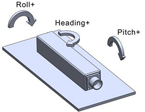
Inertial measurement unit is a device that measures the three-axis attitude (or angular rate) and acceleration of an object. In general, an IMU contains three single-axis accelerometers and three single-axis gyroscopes. Accelerometer detects the acceleration signals of object in the carrier coordinate system independently of the three axes, and gyroscope detects angular velocity signal of carrier relative to the navigation coordinate system. Measure the angular velocity and acceleration of the object in three-dimensional space and solve the object’s pose.
The difference between AHRS and IMU is that AHRS includes the embedded attitude data solution unit and heading information, and IMU only provides sensor data and does not provide accuracy. Reliable gesture data function. Actually AHRS has one more magnetic field sensor than IMU, and why AHRS is lower than IMU and needs to rely on gravity field and magnetic field? This is determined by the sensor device architecture. AHRS sensors are usually low cost MEMS sensors. The noise of gyroscopes and accelerometers of such sensors is relatively large. The IMU’s gyroscope uses fiber optic gyro or mechanical gyro or ring laser gyro. Gyro cost is high, and gyro accuracy is also high relative to the MEMS. AHRS usually combines GPS and barometers to get location information.
For more information, please contact info@sennavs.com